 |
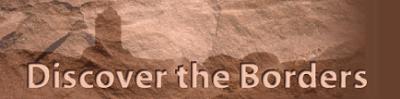
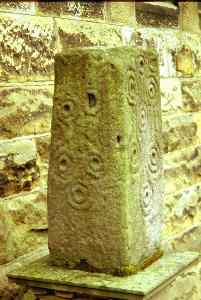
Description: On the shaft of Millholm Cross is carved a sword with the initials MA and AA above. The cross probably commemorates Alexander Armstrong, laird of nearby Mangerton Tower and one of the notorious clan of Border reivers. Ownership: Public access Situation � OS ref: NY 476861 How to get there: By car: To the south of Newcastleton on the B6357 Canonbie road. On the RHS less...
Type: Archaeological-Sites
|
 |
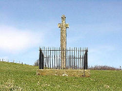
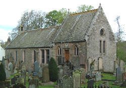
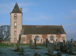
Description: Minto is a planned village designed and laid out by William Playfair for the 2nd Earl of Minto. The Church, built as part of the plan, was completed in 1831 and replaced a much earlier mediaeval building close by which was recorded as far back as 1275. Ownership: Church of Scotland Situation � OS ref: NT 566201 How to get there: By car: Off the A698 Kelso to Hawick road...
Type: Archaeological-Sites
|
 |
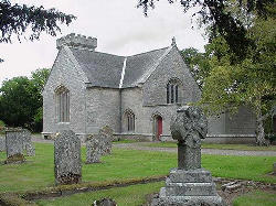
Description: Virtually no trace remains of the original church recorded in 1116 AD. The now ruined building which was built in the 18th century is outside the present village. Repaired in 1832, but abandoned about 1890, when the new church, within the village, was built. Ownership: In Ancrum Graveyard Situation � OS ref: NT 621248 How to get there: By car: Off the B6400 road, to the ...
Type: Archaeological-Sites
|
 |
Description: A carved stone cross stands on the triangular village green, where regular markets took place from 1490. Bishop Blackadder of Glasgow, as feudal lord of the village, set up a market in a failed attempt to turn the village into a centre for trade and commerce. Ownership: Public place Situation � OS ref: NT 628245 How to get there: By car: In the centre of the village of ...
Type: Archaeological-Sites
|
 |
Description: Looking over the present town of Duns, a path leads from Castle Street to the top of this hill, site of the first town. The hill is crowned by the defensive banks of an Iron Age settlement, inside which is a military fieldwork which was constructed in 1638, during the first Bishop's War. A Scottish army under General Leslie occupied the hill, fortified it and reputedly raised th...
Type: Archaeological-Sites
|
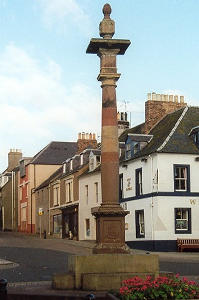 |
Description: Duns was granted the status of a Burgh of Barony in 1490 by King James IV in favour of George Hume of Ayton and his son, John. The Market Cross was a symbol of the town's commercial and civil standing. The original cross was pulled down in 1816 and reconstructed in the local Park in 1897 to commemorate the Golden Jubilee of Queen Victoria. When the town Square was refurbished i...
Type: Archaeological-Sites
|
|
Description: Dykescroft Information Centre houses an exhibition of forestry past and present and leads to Priest Hill, where there are the remains of a 2000 year old Iron Age hillfort and the sites of former farmsteads. Ownership: Forest Enterprise Situation � OS ref: NY 504877 How to get there: By car: A minor road leading from the B6357, left, going over the bridge at the south e...
Type: Archaeological-Sites
|
 |
Description: The mediaeval church dedicated to St Andrew was replaced by the present building in 1774. The western boundary walls of the kirkyard include parts of the Convent Church of St Mary the Virgin, a Cistercian nunnery founded about 1150 by Cospatrick, Earl of Dunbar. The nunnery was abandoned in the early 17th century. Ownership: Church of Scotland Situation � OS ref: NT 763413...
Type: Archaeological-Sites
|
 |
Description: The monks of Kelso Abbey founded the church at Bowden around 1128, although only some fragments in the west gable and north wall survive from this original structure. The original church was a rectangular building to which transepts were added in the 15th century. The church has been remodelled at least twice since then, the last in 1909, and, while the exterior still bears a feel...
Type: Archaeological-Sites
|
|
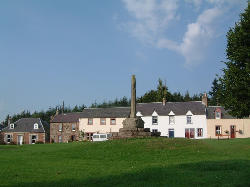
Description: In the 12th century, the village of Castleton consisted of the parish church, the houses of the villagers and the earth and timber castle of the Norman family of Soules. Little of this now survives. The churchyard of St Martin marks the site of the mediaeval church and a stone has recently been erected on the other side of the road to mark the position of the village green, and the ...
Type: Archaeological-Sites
|
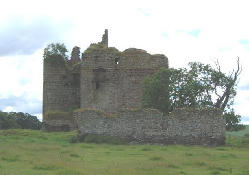 |
Description: Built about 1450 for Andrew Ker, the ruins of this castle remind one of the turbulent times during the 16th century when the Border area was the scene of continuing warfare between the Scots and the English, and, in times of cross-border peace, between the various families along the border. The Ker family and its various branches was involved in much of the fighting, various Kers ha...
Type: Archaeological-Sites
|
|
Description: Remains of the Norman parish church of Chirnside can still be seen as a blocked window in the lower part of the western tower and as an ornamental doorway through the south wall. Sundial dated 1816, situated on skewputt. Church rebuilt in 1878 and major restoration and alterations in 1907. Ownership: Church of Scotland Situation � OS ref: NT 870560 How to get there: ...
Type: Archaeological-Sites
|
 |
Description: Probably erected about 1612, when King James VI granted the village status as a Burgh of barony, although local tradition states that it is older, having been erected to commemorate the marriage of King James IV to Margaret Tudor of England. Carvings show the Scottish Thistle and the Tudor Rose. Ownership: Public access Situation � OS ref: NT 774711 How to get there: ...
Type: Archaeological-Sites
|
|
Description: Cockburnspath Church was originally a dependant chapel of Coldingham Priory. The current building was extensively rebuilt after the ravages which followed its original construction in the 16th century. Major renovation in 19th century. Unusual short round tower at one end of this rectangular building. Ownership: Church of Scotland Situation � OS ref: NT 774710 How to...
Type: Archaeological-Sites
|
|
Description: Founded in the early 12th century by monks from the Benedictine Monastery at Durham it was attacked frequently over the centuries with Cromwell leaving it a smoking ruin in 1648 as he moved north into Scotland. Little remains of the original, but fragments of the south transept and cloister can be seen. Parts of the 13th century choir remain to their full height. After extensive ...
Type: Archaeological-Sites
|
 |
Description: The present church dates only from 1899, built on the site of at least two previous buildings. The original church was severely neglected after the Reformation, and a new building was erected in 1739, itself being replaced by the current building which is still in use. Ownership: Church of Scotland Situation � OS ref: NT 692618 How to get there: By car: On the B6355 P...
Type: Archaeological-Sites
|
|
Description: Standing by the roadside, this cross was erected so that travellers would know that they were approaching the boundary of Eccles Nunnery, a Cistercian Nunnery. This priory was in existence from the late 1100's until 1609 when its property and lands were given to Sir George Hume. Ownership: On private land, but can be viewed from the roadside. There is no public access Si...
Type: Archaeological-Sites
|
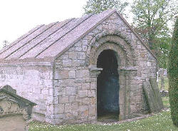 |
Description: Very highly carved Romanesque doorway, dating from the 12th century; formerly the door to the church, Now the entrance to a burial vault in the graveyard. Ownership: In the care of Historic Scotland. Situation: OS ref: NT 827558 How to get there: By car: 3 � miles north east of Duns along the A6105 in Edrom village. By public transport: regular public transport from...
Type: Archaeological-Sites
|
|
Description: This promontory was fortified in 1547 by invading English troops and again in 1557 by French forces acting on behalf of the Scottish king. The two lines of ramparts, with bastions and gun emplacements, can still be traced in the grass-covered earthworks. The headland provides a spectacular viewing point for the cliffs and their nesting seabirds. Ownership: Public Access Si...
Type: Archaeological-Sites
|
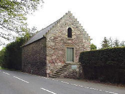 |
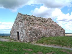
Description: A two-storey barn which was used for storing the grain which was the tithe or teind (tenth part) payable to the church. Ownership: In the care of Historic Scotland Situation: OS ref: NT 931558 How to get there: By car: In Foulden, which is 4 miles south east of Chirnside on the A6105, Chirnside to Berwick upon Tweed road. By public transport: Regular public transpor...
Type: Archaeological-Sites
|
 |
Description: Dating from 2nd century, one of a very limited number of Iron Age brochs in the lowlands of Scotland. It sits within an earlier fort which is surrounded by ramparts and ditches. Later, the site was occupied in the Romano-British period. Ownership: In the care of Historic Scotland. Situation: OS ref: NT 772603 How to get there: By car: Off the A6112, Duns to Grantsho...
Type: Archaeological-Sites
|
|
Description: Lying between Jedburgh and Hawick, these are the remains of a 16th century tower house. It was held by Margaret Home of Cowdenknowes prior to her wedding to William Turnbull of Bedrule. It is recorded as one of the towers destroyed by the Earl of Hertford during his raids which devastated the Borders in 1545. Around the house are the turf-covered remains of the houses and outbuild...
Type: Archaeological-Sites
|
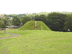 |
Description: Standing in Motte Park are the remains of this �motte and bailey� castle which was the stronghold of the Lovell family. All that now remains are the remnants of the main earthen mound on which stood the defended buildings. There are no signs now of the bailey or ditch which was the outside defensive work beyond the �wall� which surrounded the main mound. In 1912, an exploratory ...
Type: Archaeological-Sites
|
|
Description: Remains of a 13th or 14th century chapel and graveyard are enclosed within the defensive earthworks of an earlier farmstead. A low mound known as the "Cout o' Kielder's Grave" may be the grave of Sir Richard Knout (Knut) of Kielder, Sheriff of Northumberland, who died about 1290. Ownership: Public access on moorland. Situation � OS ref: NY 493960 How to...
Type: Archaeological-Sites
|
|
Description: The site of the skirmish in 1514 when, according to local tradition, a group of English marauders were put to flight by a group of young men from Hawick. The Hawick Cornet, who leads the annual Riding of the Marches, proudly carries a replica of the flag which was captured on that occasion. Ownership: On private land. Situation � OS ref: NT 533167 How to get there: By c...
Type: Archaeological-Sites
|
|
Description: The most complete Roman fort in Britain, extensively excavated, with the finds displayed in the museum amd visitor centre. Ownership: National Trust and English Heritage with Trust Situation � OS ref: NY 790688 How to get there: By car: Off the B6318 which runs parallel to and to the north of the A69, Newcastle to Carlisle road. North of Haydon Bridge. Parking. Signpost...
Type: Archaeological-Sites
|
 |
Description: Standing outside the east end of the church is an ancient carved stone. Thought to be the base of a preaching cross dating from the 9th century, it came from the foundations of the previous church building. Ownership: Church of Scotland Situation � OS ref: NT 332369 How to get there: By car: In Innerleithen which lies on the A72 between Galashiels and Peebles. By publ...
Type: Archaeological-Sites
|
|
Description: The foundations of the last monastic house to be founded in Scotland are visible in this garden. Many medicinal herbs and local varieties of fruit tree are to be found here. Interpretation tells the story of this 16th century house of the Observantine Franciscan friars and its destruction by English artillery in 1545. Ownership: Situation � OS ref: NT 650208 How to get t...
Type: Archaeological-Sites
|
|
Description: Johnnie Armstrong of Gilnockie was an infamous reiver who was a thorn in the side of the Scottish King James V. No matter what the King did, Armstrong went his own way and did his own thing, giving fealty to none. In 1530, the King decided that the time had come to end this challenge to his authority, so having gathered an army of 10,000, he set off for the Borderlands. Armstrong,...
Type: Archaeological-Sites
|
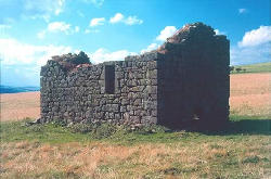 |
Description: A good example of a 16th century bastle house, or fortified farmhouse, which provided shelter from the cross-border reivers or raiders in the days before peace reigned between Scotland and England. A lower floor provided a store and shelter for the few animals, and a removable stair up to the living quarters gave the occupants the chance of holding out until help arrived. Owners...
Type: Archaeological-Sites
|
|
Description: The Church of St Bride was part of the Diocese of Glasgow, based in Strathclyde and which paid particular honour to saints from the celtic nations � Scotland, Wales and Ireland. First recorded in 1116, there is now no evidence of the original medieaval church, the present building being from 1778. Ownership: Church of Scotland Situation � OS ref: NT 320334 How to get there...
Type: Archaeological-Sites
|
 |
Description: The site of the former 13th century parish church can still be made out as a turf-covered two cell structure close to the centre of the churchyard. The smaller of the two cells represents the former chancel, where the priest officiated, and inside is a well preserved hogback tombstone. Scandinavian settlers developed this rare form of burial monument in the 10th � 12th century. Al...
Type: Archaeological-Sites
|
 |
Description: Littledean Tower, near Ploughlands Farm, Maxton was formerly a very important defended house, for many years the home of the Kers of Littledean, a branch of the Kers of Cessford. It makes use of the unusual site which it commands with the River Tweed on the north side and a burn to the east. The west end was built in the form of a half-moon and the east an oblong square � overall i...
Type: Archaeological-Sites
|
 |
Description: The ruins of the famous castle of Roxburgh, favourite of Scottish kings, seated on its massive grassy mound between the Rivers Tweed and Teviot. Ownership: On Roxburghe Estates land. Situation: On the banks of the River Teviot, about one mile out of Kelso. OS ref: NT 712337 How to get there: By car: Drive over Kelso Bridge going South, turn immediately along the A699...
Type: Archaeological-Sites
|
|
Description: The Market Square was the most important part of the mediaeval town. There the commercial activity was based, with the various separate markets taking place close by. The Pant Well was built in 1898, and still marks the commercial centre of the town. Ownership: Public access Situation � OS ref: NT 469284 How to get there: By car: In the centre of Selkirkwhich lies betwe...
Type: Archaeological-Sites
|
|
Description: An area of water meadow across which runs the Southern Upland Way. This site saw a battle in July 1526, when Sir Walter Scott of Branxholm tried unsuccessfully to rescue the young King James V from the dominance of the Earl of Angus with his Ker and Home allies. In the ensuing rout, Scott lost eighty men and the victors lost Ker of Cessford. Ownership: Private land but open r...
Type: Archaeological-Sites
|
 |
Description: Founded by David de Olifard in the 12th century and subsequently granted to the Benedictine monks of Coldingham priory. The exterior still shows much of the original stonework, particularly in the east end which still has three Norman windows. Ownership: Church of Scotland Situation � OS ref: NT 649364 How to get there: By car: In the village of Smailholm, on the B639...
Type: Archaeological-Sites
|
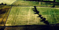 |
Description: The most important Roman military complex between Hadrian's Wall and the Antonine Wall guarded and secured the crossing of the Tweed at Newstead in the 2nd century AD. Excavations have revealed some of what was going on there, but much has still to be done. Helpful boards and viewing platforms. Guided walks arranged throughout the summer months. Ownership: Open access to t...
Type: Archaeological-Sites
|
|
Description: An early Christian stone from the 5th Century AD, which commemorates the burial site of two Christian princes � Nudos and Dumnogenos, sons of Liberalis. Ownership: On private ground. Stands within a small enclosure, beside a farm track a short way from the public road. Situation � OS ref: NT 348274 How to get there: By car: Close to the A708, Yarrow Water road from Selki...
Type: Archaeological-Sites
|
|
Description: The ruins of the medieval church of "Zedon" where, in 1388, Scottish nobles planned an invasion of England watched by an English spy. The spy gave himself away, but bought his life by betraying the English plans. This helped the Earl of Douglas, the Scots leader, to gain victory over the English led by Harry "Hotspur" at the Battle of Otterburn. Douglas, however,...
Type: Archaeological-Sites
|
 |
Description: Midway between Edinburgh and the magnificent Border abbeys from the 12th to the 17th century stood a mediaeval hospital � a refuge for travellers and the needy on the Royal Road, the main Anglo Scottish highway. The excavation of the site and the ensuing research began in 1986 and are ongoing. Ownership: Private Situation � OS ref:NT 452584 How to get there: By car...
Type: Archaeological-Sites
|
|
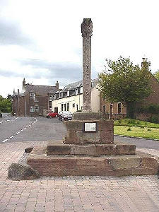
Description: Although the original village dates back to the 11th century, the present village was laid out as a planned village in the 18th century. The market cross stands on the Village Green where it was erected as a symbol of the commercial status that Swinton once enjoyed as a market town. As the Green is also a football pitch, the Market Cross, standing as it does in the middle of the pit...
Type: Archaeological-Sites
|
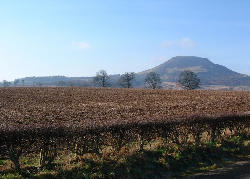 |
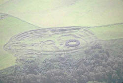
Description: The summit of Eildon North Hill is crowned by the largest hillfort in Scotland. Built in the 10th century BC, this fortified site contains platforms for nearly 300 huts and may have served as a focus for periodic gatherings by the scattered hill communities. When the Romans arrived in the Borders in the late 1st century AD, they built a watch tower on the summit of the hill and th...
Type: Archaeological-Sites
|
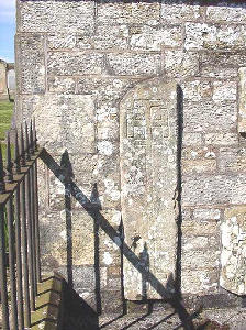 |
Description: No trace survives of the mediaeval church which served the parish of Ettleton until 1604, except for the collection of carved stones set into the graveyard wall. Amongst these are several mediaeval tomb slabs and a cross head. The churchyard stands between the enclosed landscape of narrow strips, which represent 18th century land allocations to the local community, and the upland ...
Type: Archaeological-Sites
|
|
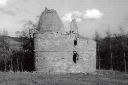
Description: First recorded in 1423 as the �New Werk� to replace the �Oldworck�. Attacked twice during the 16th century, it was eventually destroyed by Cromwell�s forces in 1650. In the 18th century it was stripped and the dressed stone recycled. There is still evidence of the 16th century barmkin or courtyard wall, with its numerous gunloops. Ownership: Tower is NOT open to the public, an...
Type: Archaeological-Sites
|
|
Description: This village was planned from scratch by the 3rd Duke of Buccleuch. At this time in the 18th century, Castleton was a series of scattered farms with a church. The Duke's aim was to develop handloom weaving and, by 1800, he had built 220 houses, many of which had a large front window to allow the maximum amount of light for the weavers. The local museum has details of the past h...
Type: Archaeological-Sites
|
|
Description: A small stone circle erected between 5000 and 4000 years ago, as a place of ceremonial worship and perhaps burial. Lord Soules of Hermitage Castle is said to have been wrapped in lead and boiled to death here. Ownership: Public access Situation � OS ref: NY 517973 How to get there: By car: Along a footpath leading east from the B6399 Newcastleton to Hawick Road, between...
Type: Archaeological-Sites
|
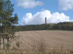 |
Description: A 150 foot tower, built between 1817 and 1824 to commemorate the Battle of Waterloo, standing on a hill top near to Harestanes Visitor Centre. The tower itself is NOT open to the public. Ownership: Private land. Situation � OS ref: NT 653263 How to get there: By car: For walkers, the best way is to park at the Harestanes Visitor Centre and then follow the marked walk to...
Type: Archaeological-Sites
|
 |
Description: At Pennymuir the ramparts and entrances of two marching camps are particularly well preserved. Close to what is now the border, they are a reminder of the many occasions on which Roman legions marched north from York and Hadrian's Wall to reach their bases at Trimontium and further north. It was a major route into the area from the 1st to 4th centuries. Dere Street itself can b...
Type: Archaeological-Sites
|
|
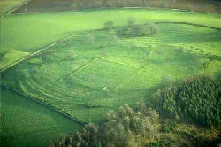
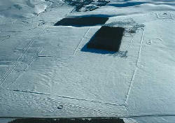
Description: This hill is crowned by the remains of an iron age hillfort which is marked by the two lines of ramparts and the sites of several circular houses within. This site was the homestead of a farming community about 2000 years ago. Seven stone cairns arranged to outline an iron age house depict aspects of the history of the district. Excellent views of the Tweed Valley from this view...
Type: Archaeological-Sites
|
 |
Description: Although an inscribed stone set into the south wall claims that there has been a church on this site from before 900AD, this church was built in 1703 and replaced the mediaeval church of "Poulworth" which was dedicated to David de Bernham, Bishop of St Andrews in 1242. The crypt is the family vault of the Hume family, and was the famous hiding place of Patrick Hume when h...
Type: Archaeological-Sites
|
|
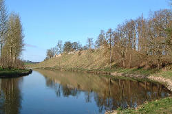
Description: This fine bridge dates from 1770 and was an important element of the Duns to Grantshouse and Dunbar Turnpike which was opened in the 1840's. Today there are fine views along the River Whiteadder. Ownership: Public Situation � OS ref: NT 787568 How to get there: By car: On the A6105 Duns to Grantshouse road where it crosses the River Whiteadder just south of Prest...
Type: Archaeological-Sites
|
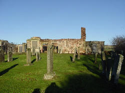 |
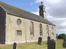
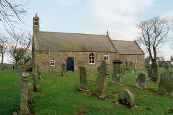
Description: The first Preston Church was built in the 12th century and belonged to the Bishopric of Dunkeld. Stones from this period with Norman carving were incorporated into the present church which was abandoned in 1718 when the parish was united with Bunkle. The churchyard continued in use and a number of family memorials are amongst the ruins. Ownership: Church of Scotland Situatio...
Type: Archaeological-Sites
|